 Weather Radar Pro


Weather Radar Pro
frei
nicht verfügbar
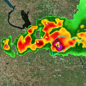
Professional radar data that covers the United States, Europe, and the Caribbean.Animated weather radar. Radar includes a rain/snow line, frontal boundary locations, and icons indicating the location and size of hail. Radar images include high resolution base reflectivity at multiple scan angles, enhanced echo tops, vertically integrated liquid, correlation coefficient, differential reflectivity, 1 hour precipitation total, and storm total precipitation. Radar data for Europe and the Caribbean only includes base reflectivity.
It's professional data you don't want to be without.
It's professional data you don't want to be without.